Black Elk Peak, formerly Harney Peak, is the highest point in the Black Hills and one of the most sought-after hikes in this area.
In case you aren’t aware of it (and as I outlined in this post), the name of this mountain changed just a few years ago and they’re still working on updating all the signs and maps.
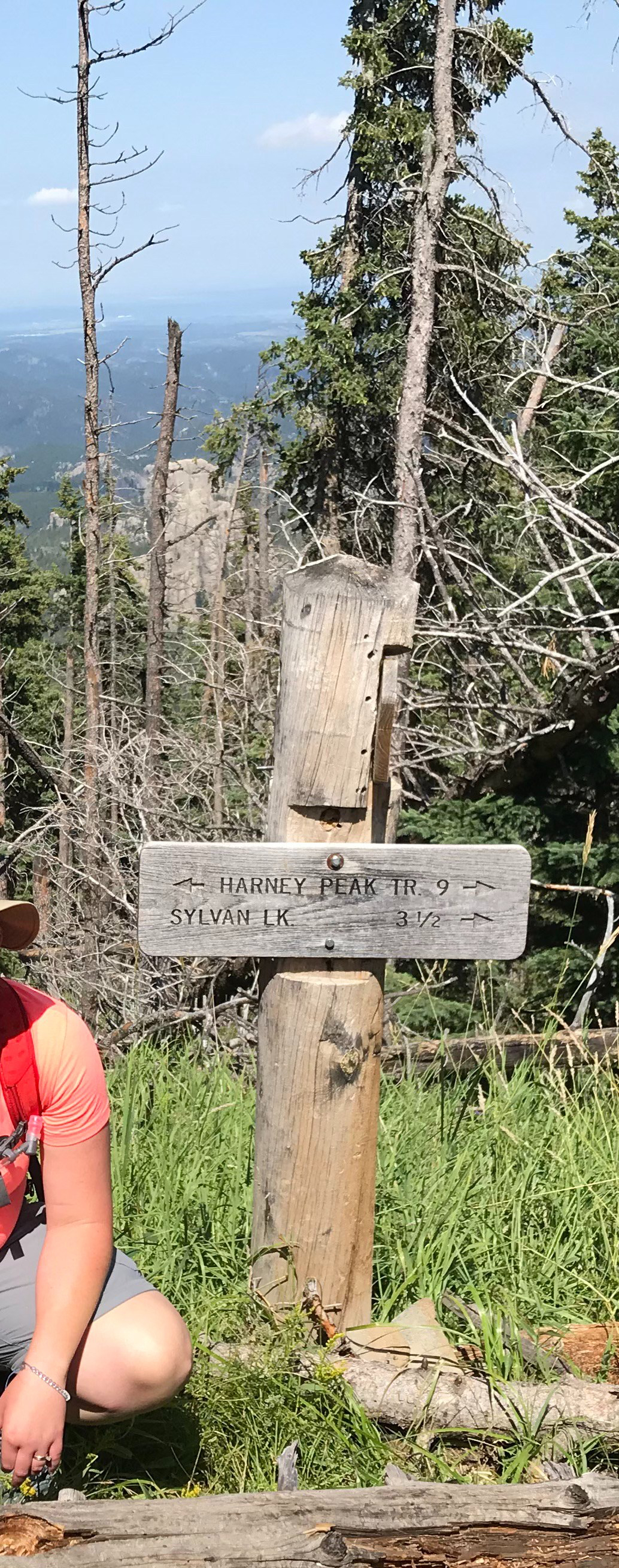
There are multiple trail options for getting to the summit. The most popular route is the southern portion of Trail #9, the Black Elk Peak Trail, that starts at Sylvan Lake. However, in this post, I’m going to talk about the far less-traveled (and far more difficult) northern portion of this same trail.
It is a little confusing because the names are the same. Be watchful for this (there are signs!)} This portion of the trail is actually shorter than the southern route, but it is far steeper, which is why it is more difficult.
Accessing the Black Elk Peak Northern Route Trailhead
There are a number of ways to access this portion of the trail. One of the easiest is from the Willow Creek Horse Camp off of Route 244. You will find it directly across the road from the Mount Rushmore KOA campground (and around six miles west of Mount Rushmore.
The Willow Creek Trail is an easy and fairly short loop that makes for a great, quick hike. It is only around two miles in length and you can enjoy it in either direction. You will need to start on the Willow Creek Trail to reach the Black Elk Peak Trail which branches off about halfway through the Willow Creek loop.
1st Attempt to Conquer Black Elk Peak, the Hard Way
We’re standing at Black Elk Peak, we’ve been on the trail for five hours, the guidebook we’d consulted said the trail options we chose were only around eight, total miles long. We now KNOW that can’t be right as our GPS says we’re well over five miles into the hike and we’ve only reached the summit. It’s 5 p.m. and…it’s starting to drizzle…
We had used the Lost Cabin trailhead off Palmer Creek Road to ascend the mountain on this attempt. We weren’t sure if we’d make it the whole way or just turn back at some point, but at lunchtime, we were nearly four miles in and the book had said it was only an eight-mile trek so…this is a lesson in listening to your gut. When your guidebook (and/or GPS) say one thing, but while looking at the map and using human logic your gut says another…ALWAYS listen to your gut! 😝
Fortunately, it was Memorial Day weekend so we had guaranteed daylight until 8:30 pm or so, and we had headlamps with us. (This was one of the only, true, “uh oh” moments I’ve ever had on a trail. The thought crossed my mind that we could be facing a long, cold night.).
We did, eventually, make it down safely, and with daylight remaining. We even managed to save one set of dry pants, each, to change into when we got back to the car!
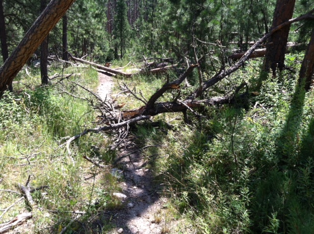
After descending this trail in drier conditions, I’m somewhat impressed we made it down as safely and easily as we did. Water trickles over the large, boulder steps on sunny days, so, on rainy days, it can turn into a veritable river in spots!
The path is steep and technical enough on its own, in the rain and growing darkness, it can get muddy and slippery very quickly–portions of it literally turn into mini-waterfalls from water running down the slope! I thank Mr. Trekker for suppressing my tendency to rush…I hate this trail. 😝
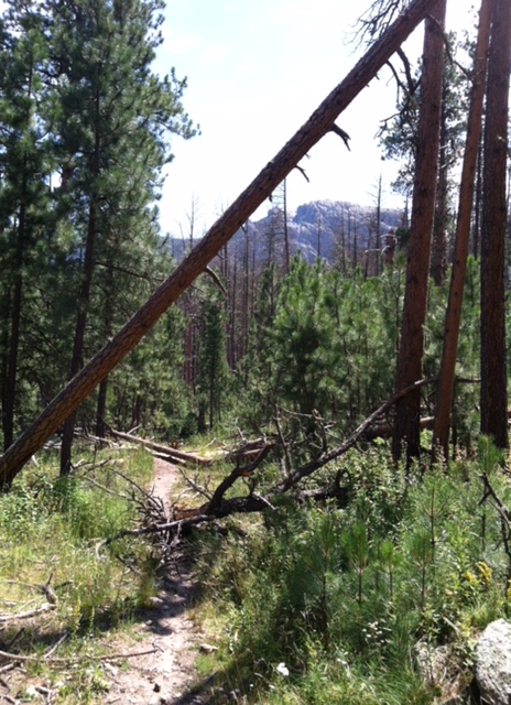
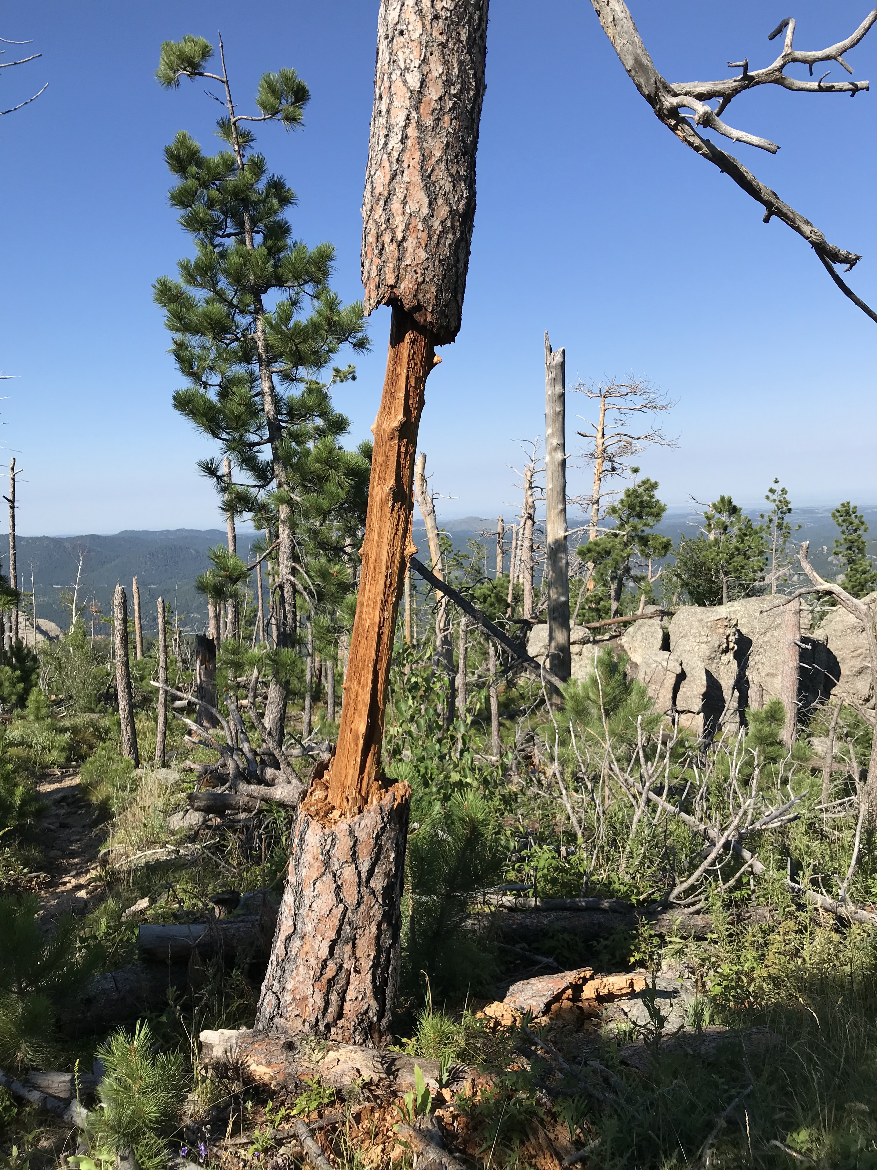
This trail system is a beast! Mr. Trekker and I almost had a dead limb fall on us on another, nearby trail during a hike a few years ago, on a day that wasn’t particularly windy. 😳
2nd Attempt to Conquer Black Elk Peak’s North Route
It’s a beautiful, sunny day. We began hiking fairly early in the morning. One problem with Trail #9 is its exposure. It used to be fairly shaded…until the pine beetles had their way. That and the resultant logging to lessen the danger of falling, dead trees has culminated in A LOT of sun exposure. Fortunately, a breeze is often present…but not always…
The heat got the Trekkers on this day (especially me). I’ve mentioned before that I don’t do well with heat. We made it about halfway to the summit, to the point where it really starts to get difficult.
I call this “the Boulder Section” because you have to clamber across a long length of boulders while negotiating a rather steep incline–this is the section that becomes mini-waterfalls in wetter conditions.
After this section comes the first phase of mind-numbing switchbacks (that’s right, I said FIRST! 😝) You then proceed to a flatter section, before the final phase of switchbacks, which takes you to the junction with the Black Elk Peak Summit Trail (a short, spur trail).
About the time we reached the “Boulder Section”, I started suffering from stomach cramps and nausea, similar to what I experienced when I became overheated hiking in Glacier National Park several years ago. Due to this, we made the wise decision to turn back…have I mentioned that I HATE THIS TRAIL?! 😩
3rd Attempt…SUCCESS!!!
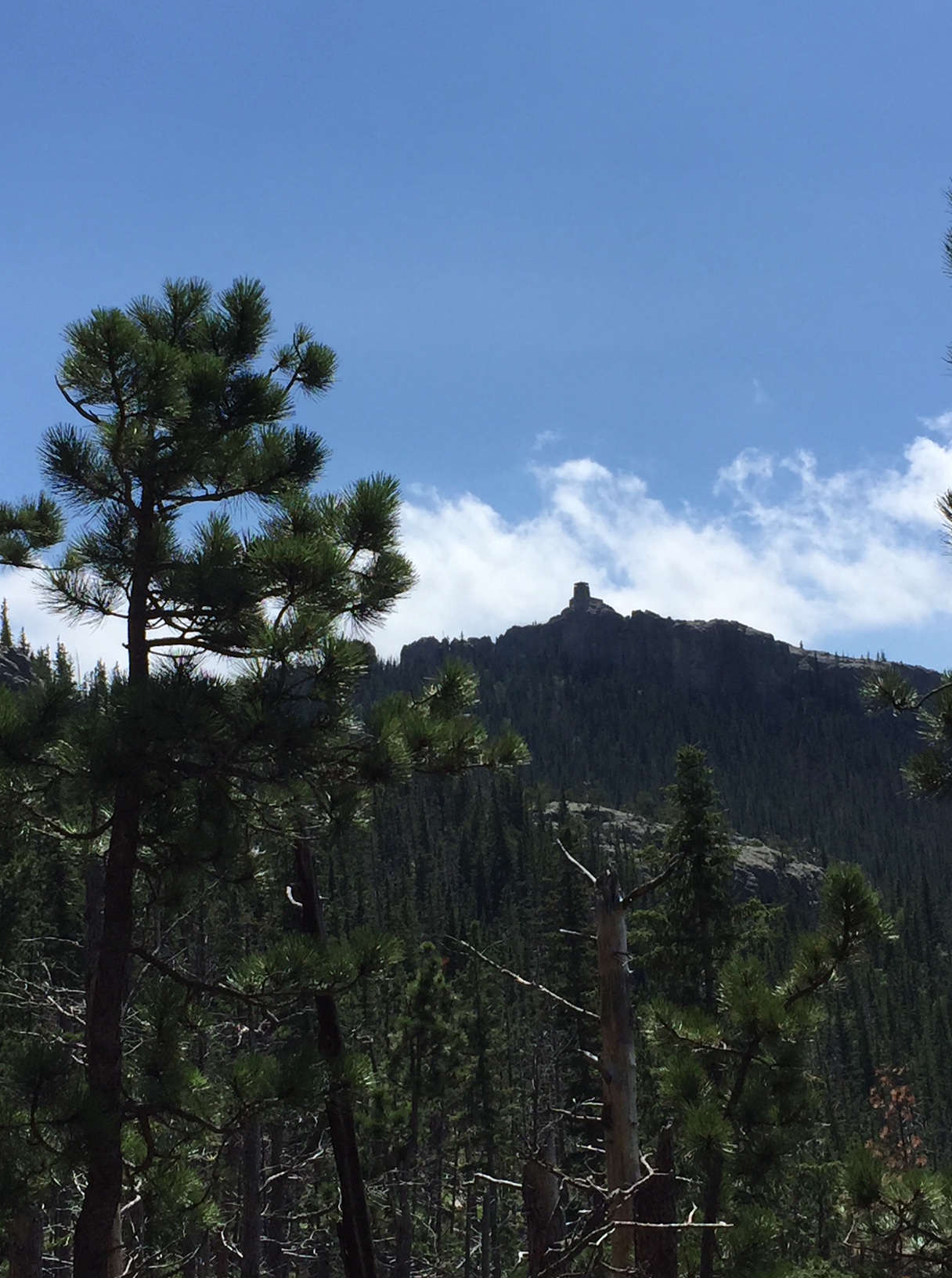
It’s a, fairly cool, July day (lower 80’s). Earlier that week we had returned from a 10-day trip to the Colorado High Country that I outlined in these four posts. Due to hanging out at 8000 – 10,000 feet throughout that trip, we were especially acclimated to the altitude. (Black Elk Peak, at a little over 7000 feet, is not only the highest peak in the Black Hills, but it is also the highest peak in the country east of the Rockies). I honestly felt in my gut that if I ever hoped to vanquish this monster, this was the time to do it. All conditions were perfect, we were both feeling great and it was a beautiful day!
We made it through the easy, early section with no difficulty. We happily said “hello” to others on the trail, and avoided the occasional “remnant” from horses that had gone before us. 🤥 We reached “the Boulder Section”…my first nemesis. We conquered that fairly easily as well!
Then, we reached the first section of switchbacks. Fortunately, the shade was on our side at that time of the day. It was starting to hurt…but we made it through.
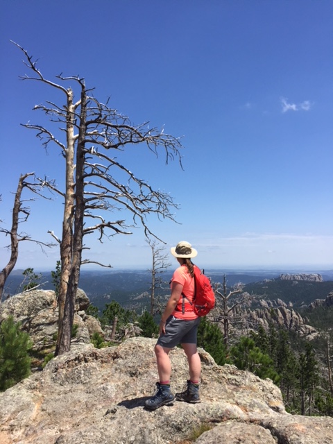
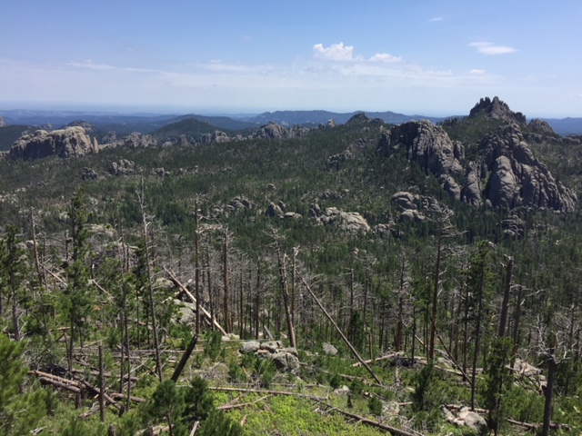
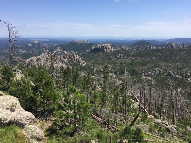
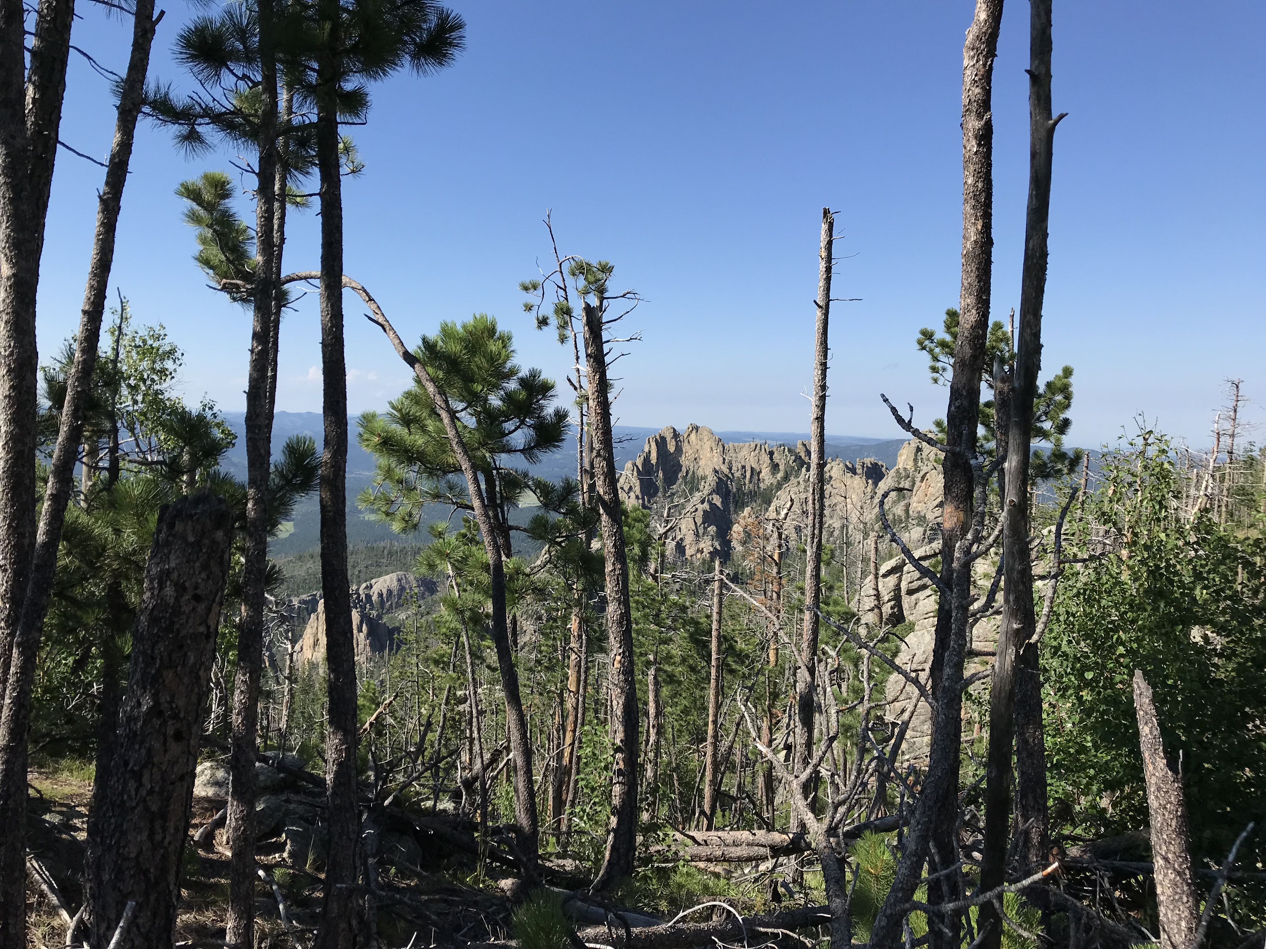
The next section traverses a ridge that parallels Black Elk Peak, so it is fairly flat. This is beneficial as it’s also fairly exposed.
This area affords lovely views of the crags that lord over you from nearby peaks, and the panoramic vistas of the plains to the east (on clear days). Buzzards soar on the thermals high above your head (waiting for beleaguered hikers to falter? 🤔) There are also several, lovely, lookout points along the way that make for a great break/lunch spot. We stopped at a couple, both on the trek up and down the mountain.
Then…we hit the final section of switchbacks. Both of us had just started feeling the altitude a bit (we were pushing 7000 feet at that point). This was the only spot where I started feeling ill. Fortunately, it was still early afternoon and we were in a shaded, quiet area, so we were able to take some time to rest and recover.
And then…
…we began our final push…
…as we rounded one, final switchback…
…and crested one, final rise in the trail…
…we saw a brown sign appear in the distance, indicating our destination was just ahead…
…WE HAD MADE IT!!! 😁
Seriously ya’ll, I almost broke down in tears! I get emotional now, just thinking about it. It had taken us three attempts to conquer this beast!
I maintain this is the toughest trail I’ve ever completed in the entire Black Hills. It has a reputation for being “a doozy”. It’s long, it’s difficult, it’s exposed, and the weather can change at a moment’s notice. Fog and rain can seep in, which is an experience unto itself. (You won’t have the grand vistas that you’ll see on clearer days, but the granite columns materializing through the mist create a spooky gloom that is definitely worth experiencing, just watch your footing!)
Descending the Northern Route of Black Elk Peak
On the way down…we ran out of water (seriously). With the exception of another difficult trek in Glacier National Park, this almost NEVER happens! We usually return with a liter or so left in each of our water bladders.
It was projected to be a fairly cool day and we wanted to limit weight as much as possible– due to the strenuous hike–so we didn’t fill them quite to their max, fill line. I will NEVER make that mistake, in July, again!
Fortunately, by the time we ran out, we were only about 1.5 miles from the trailhead, it was all downhill from there and we had reached the easier portion of the trek. (Also, fortunately, a gas station in Hill City, the nearest town, had LARGE Gatorades for sale! 😜)
Have I mentioned that I HATE this trail?! I don’t think I’ve ever said that about a hike before. I am SO GLAD that we finally beat this brute, but seriously, I don’t know that I’d do it again.
I may consider it with two cars, one parked at Sylvan Lake so you can take the easy route up, and the other parked at Willow Creek trailhead as descending the hard route isn’t too bad…as long as it isn’t raining. 😝 (Or, find a nice friend who will shuttle you between the two points). Or I would try ascending the Lost Cabin trail and descending this one again.
Below are some pics from our day of achievement! 😁 (Thanks, as usual, to Mr. Trekker for some of these!)
Conquer Fear by Reaching your Goals
This trail had beaten us twice before, but we had finally defeated it! If we hadn’t already been acclimated to the altitude, it may have won again. This was a personal goal of mine that I had wanted to achieve for years!
This trail had made me sick, it left me with (several) blisters, it hurt me, it caused lingering anxiety to even think of attempting it again, and it pushed the limits of my endurance. But…I beat it!
Reaching this goal was an incredibly empowering, inspiring experience. This was, truly, my “white whale”. It’s hard to express my sense of accomplishment for finally completing this hike. I know others have done it and claim it “isn’t that bad”. I know it’s not a “14-er”, but so what? I don’t hike “14-ers”! 😉 This was a personal goal and desire I had set for myself and I had achieved it! What could be more empowering than that!
I don’t mean to sound like I’m bragging. My point is just that, each person has their own, personal goals, whether they be to learn a new skill, to conquer a specific challenge, etc.
Don’t compare yourself to others. Only be concerned that you push yourself to expand your comfort zone. It doesn’t matter what the goal is, as long as you strive to achieve it and, perhaps, find a way to trounce a few personal demons along the way. 👊
Have you attempted this trail? What other difficult goals have you set for yourself and achieved? Tell me about your experiences in the comments!
Did you enjoy this post? Pin it!
Like what you read here today? Please feel free to leave a comment, like or share this post! Add your email at the bottom of the page, or the sidebar to the right, to be notified when a new post is published. By signing up for the email list, you will also receive a free copy of the Tranquil Trekker’s Top 10 Tips of Trekking Do’s and Don’ts!
You can also follow the blog on social media by clicking the links below!