The Norbeck Trail is a beautiful, lesser-traveled hiking route situated within the Black Elk Wilderness. This is found within the boundaries of Custer State Park in the Black Hills of South Dakota.
How do you get to the Norbeck Trail in Custer State Park?
There are actually two trailheads to access the Norbeck Trail:
If you want a shorter hike and want to hit the more difficult, steeper sections sooner (while you have more energy) the Upper Norbeck trailhead comes first. It is located about .3 miles east of Sylvan Lake and about .1 miles east of the trailhead for the Cathedral Spires (all on the Needles Highway, Route 87.)
It’s kind of hard to find the trailhead because you can’t see it from the road and there isn’t any sign. Basically, once you pass the trailhead for the Cathedral Spires, start watching for a paved lane going off to the left. That’s the trailhead. (Sorry, that’s about the best description I can give. 😝)
To reach the main Norbeck trailhead, take Route 87 to Forest Road 345 (Camp Remington Road). Then take Iron Creek Horse Camp Road (which will be on your left). Watch for signs for the Iron Creek Horse Camp and the Iron Creek Centennial Trailhead as they’re both, also, found on this road. You will actually park at the horse camp, or just outside of it if the gates are closed (when we were there in mid-April the campground was still closed for the winter.)
Note: the Needles Highway is closed to vehicle traffic during the winter months. You can hike, snowshoe or ski it though (which can be a lot of fun!)
What you will see on the Norbeck Trail, in the Black Hills
The trail is comprised of picturesque, rolling terrain. It’s well-marked and wide enough for two people to walk side-by-side in some places. There are several water crossings that are small enough that they’re easy to cross but big enough to offer relief and respite on a hot day.
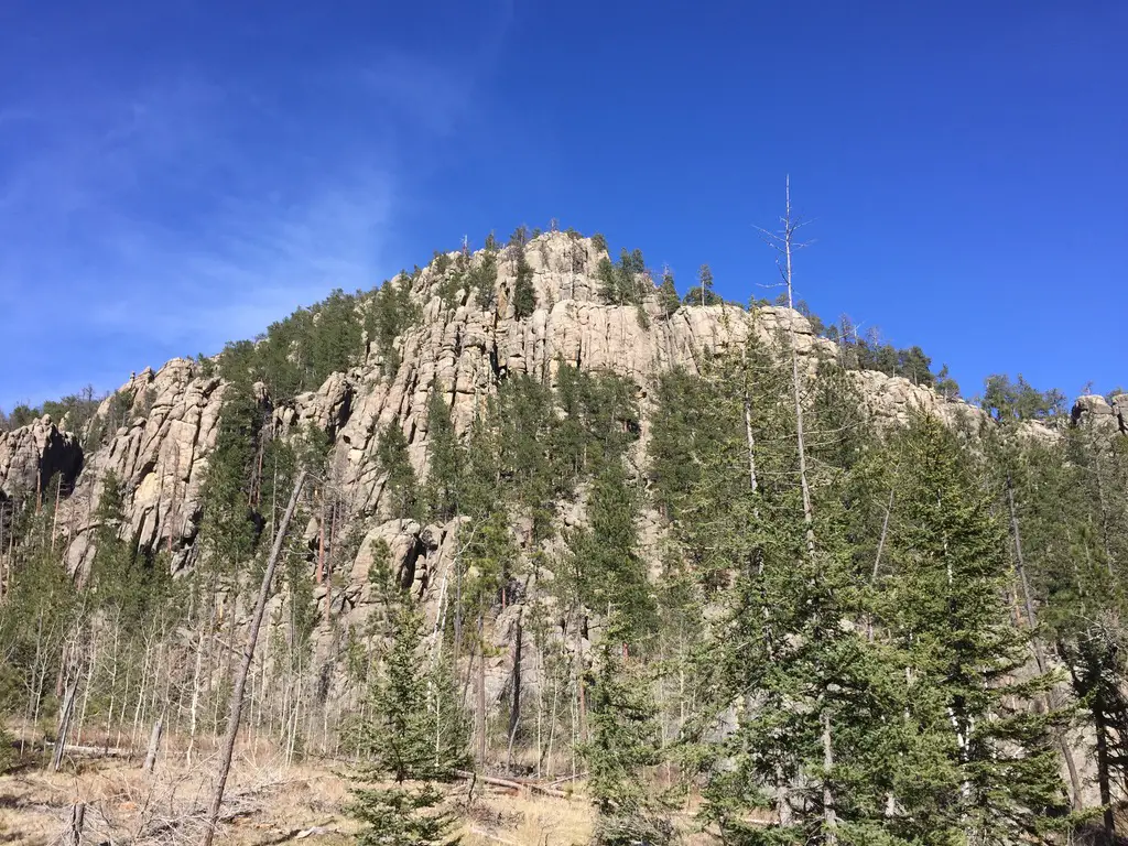
The ecology found along the length of the trail varies greatly from moist, almost temperate rainforest near the base, to dry, alpine forest near the top.
As you trek through these various ecosystems take note of the abundance of spruce trees in certain areas–usually on the northern slopes–that denote a wetter climate (you usually only see this variety in wetter locations in the Hills.)
What is the difficulty level of the Norbeck Trail?
The route is steep in parts, but the elevation changes are fairly moderate until you near the terminus of the trail where it joins with the Little Devils Tower trail. These last 2.5 miles of the trail gain 1000 feet in elevation! (To compare, we gained the same elevation amount on the Misty Moon trail in the Bighorn mountains of Wyoming over the course of five miles!)
This more difficult area is beautiful, though, as it snakes through a canyon complete with rocky, craggy overhangs and caves. You’ll see the backside of the Cathedral Spires towering over you to your left, and if you turn around you will be treated to beautiful views of the Southern Hills and plains to the south.
A word of advice: never let your focus on completing a trail keep you from looking around–and behind you! You never know what incredible views you may be missing if you’re solely focusing on the trail in front of you.

This trail doesn’t really “go” anywhere, per se, it’s more of a connector to other notable trails. It can be combined with different routes to form various loops depending on how long you wish to spend in the Wilderness Area. From the trailhead to the junction with the Little Devil’s Tower Trail, the route is a little over five miles (one way)–and as mentioned above it gets steep–so plan for a full day’s hike when considering this option.
We really enjoyed the hike and the ever-changing scenery was beautiful. There were some gorgeous vantage points and numerous opportunities for wildlife sightings. This trail is less well-known and, therefore, more secluded.
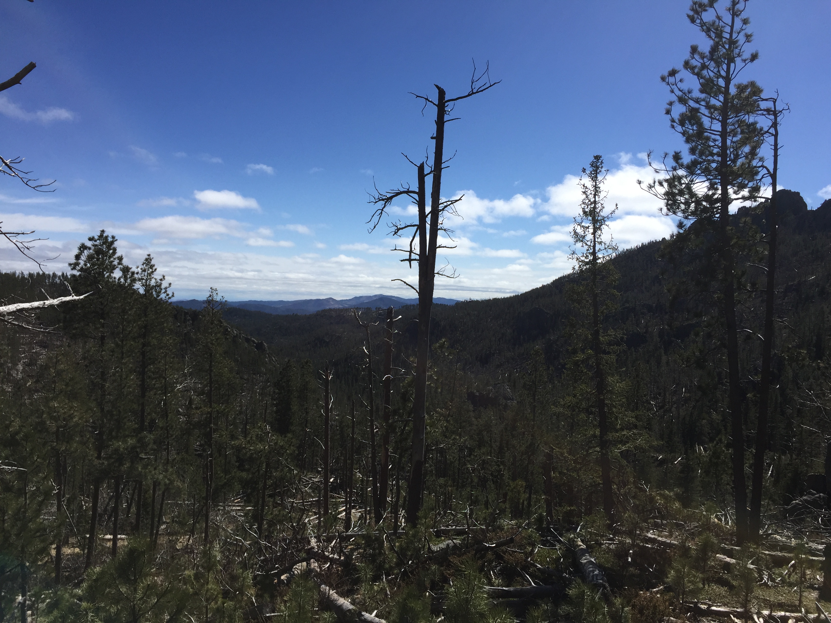
A portion of the trek does run near Route 87, for a time, so the summer months may be busier. Certain areas of the trail also traverse old burn scars so, if traveling in the summer, be prepared for lack of shade and a hot hike in some parts.

As with many other areas in the Black Hills, be watchful for deadfall as well as dead trees that remain, precipitously, standing (and their hanging, broken branches). These are remnants of the recent pine beetle infestation, and they can fall at any time, even on not-so-windy days.
If you’re looking for a fairly easy day hike, with nice views and few people, consider the Norbeck Trail!
Have you ever hiked this lighter-use trail? If so, tell me about your experience in the comments!
Did you enjoy this post? Pin it!
Like what you read here today? Please feel free to leave a comment, like or share this post! Add your email at the bottom of the page, or the sidebar to the right, to be notified when a new post is published. By signing up for the email list, you will also receive a free copy of the Tranquil Trekker’s Top 10 Tips of Trekking Do’s and Don’ts!
You can also follow the blog on social media by clicking the links below!